Urban Climate Walk: City of London | A research-led programme for urban climate learning
Cities do not simply experience climate; they actively shape it. The form, density and arrangement of buildings govern how sunlight, heat, air and moisture move through urban space, influencing comfort, health, energy demand, air quality and resilience. Architecture and urban form function as critical urban climate infrastructure, regulating the everyday distribution of exposure, shelter and environmental risk across the city.
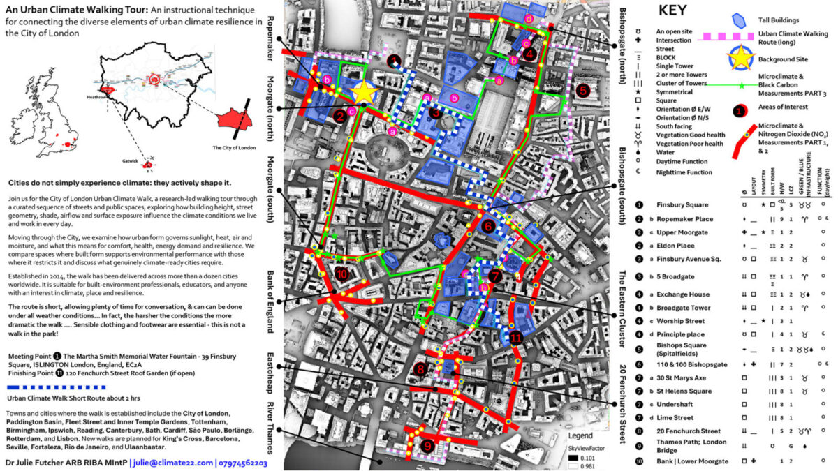
The City of London Urban Climate Walk, established in 2014, was developed as a method for translating complex urban climate knowledge directly into built-environment practice. It is a research-led, field-based programme that uses the city as a live laboratory for observing how urban form shapes local climate conditions. Drawing on measured evidence, urban climate research and direct street-level observation, it examines how building height, street geometry, surface exposure, shade, airflow and access to sky influence environmental conditions, both outdoors and inside buildings. It is designed for built-environment professionals, educators, and wider audiences interested in climate, place and resilience.
The walk investigates these relationships in real time, bringing architectural knowledge and urban climate research together to examine how spatial configuration and surface characteristics influence the exchange of energy, air and water across the urban environment. In turn these abiotic processes, including solar access, airflow, thermal balance and hydrological movement, shape biotic outcomes: human comfort and health, vegetation viability, evapotranspiration and biodiversity resilience.
Because these characteristics are embedded in urban morphology, in the structure and evolution of streets, plots, blocks, building fabric and surface properties, the environmental conditions they establish endure. Spatial decisions lock in conditions across vertical and horizontal scales, with effects that vary across the day and across seasons. The same enclosure that reduces daytime temperatures through shading may trap heat at night; the street geometry that limits ventilation in summer may buffer cold winds in winter; the solar access that drives overheating risk in one season supports passive solar gain in another. These effects redistribute solar access, ventilation opportunity, heat storage, pollutant dispersion and environmental exposure across streets, neighbourhoods and buildings, shaping patterns of comfort, risk and resilience across the full annual cycle and for decades, if not centuries, to come.
Urban morphology also sets the conditions for biotic and hydrological processes. Where geometry and surface properties support moisture retention, permeable surfaces and vegetative cover, cooling through evaporation and transpiration is possible. Where they do not, where hard surfaces dominate, drainage is constrained and sky access is limited, both biotic cooling and effective water management are compromised. These are not separate systems; they are expressions of the same underlying spatial logic.
Moving through a carefully choreographed sequence of streets and public spaces, participants compare conditions of enclosure, exposure and microclimate, and discuss how these are shaped by the form and function of the city. A central theme is that built form sets baseline climate conditions. Materials, surface treatments, reflective façades, vegetation and high-performance technologies all matter, but they operate within limits established by urban geometry. Where geometry supports access to light, air and moisture, vegetation can contribute meaningfully to cooling, shade and humidity regulation. Where it does not, these processes are constrained regardless of what is planted or installed. The walk makes this hierarchy visible by comparing spaces where built form supports environmental performance with those where it restricts it.
These effects are measurable, visible and lived. If we want climate-ready cities, we must treat urban form and architecture as critical urban climate infrastructure, governing shade, ventilation, thermal refuge, pollutant dispersion and long-term habitability.
Towns and cities where the walk methodology is established include the City of London, Paddington Basin, Fleet Street and Inner Temple Gardens, Tottenham, Birmingham, Ipswich, Reading, Canterbury, Bath, Cardiff, São Paulo, Borlänge, Rotterdam, and Lisbon. New walks are planned for King’s Cross, Barcelona, Seville, Fortaleza, Rio de Janeiro, and Ulaanbaatar.
Organisers
Dr Julie Futcher ARB RIBA MIntP
Chair, RIBA London Climate SIG | Co-founder, North Atlantic Urban Climate Action Group
For enquries: julie@climate22.com
Dr Julie Futcher is a chartered architect, researcher and educator specialising in urban climate and climate-responsive urbanism. Her work focuses on translating urban climate science into built environment practice, positioning architecture and urban form as critical urban climate infrastructure.
Julie developed the Urban Climate Walks methodology as a place-based way of making these processes visible and accessible. The walks use the city as a live climate classroom, exploring how buildings, streets, open spaces, materials, vegetation and urban form shape heat, shade, airflow, comfort, flood risk and resilience at street and neighbourhood scale.
Julie is Chair of the newly established RIBA London Climate SIG, which is being developed to support wider engagement with urban climate thinking across architectural and built environment practice. She is also co-founder of the North Atlantic Urban Climate Action Group, a network of independent urban climate academics and practitioners working across urban climate science, architecture, engineering and environmental design, and an Associate Lecturer at Central Saint Martins, University of the Arts London.